
Cyclone Dikeledi: Monitoring Natural Disasters from Space
The Copernicus Sentinel-3 mission captured Cyclone Dikeledi south of Madagascar on January 16, following its destructive impact across southeastern Africa. Originating as a tropical storm, it intensified into a cyclone and impacted several regions, including northern Madagascar and Mayotte, already recovering from a previous cyclone. The satellite imagery provides critical data for monitoring the cyclone’s progression and facilitates effective weather forecasting.
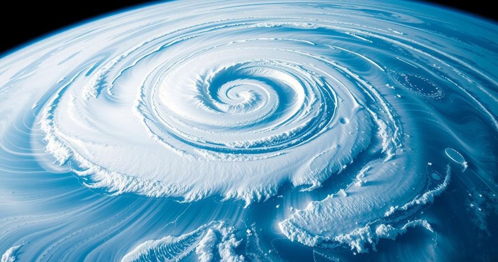
On January 16, the Copernicus Sentinel-3 mission documented Cyclone Dikeledi as it passed south of Madagascar, just days following its landfall on Africa’s southeastern coast, where it caused considerable destruction across various nations and islands. After developing into a tropical storm between Indonesia and Australia earlier in the year, Dikeledi intensified while moving westward through the Indian Ocean, ultimately reaching cyclone status upon striking northern Madagascar on January 11.
Following its initial impact, Cyclone Dikeledi affected additional regions in southeastern Africa, including Mozambique, Comoros, and Mayotte. Notably, Mayotte was still reeling from the damages inflicted by Cyclone Chido, which had struck the area in December. Copernicus Sentinel-3 plays a vital role in delivering data on large-scale events impacting extensive areas.
This specific image reveals the cyclone’s estimated width of approximately 500 kilometers, with an eye measuring around 25 kilometers in diameter. The mission’s design enables the monitoring and understanding of global dynamics in near-real time, providing significant support for oceanic and meteorological forecasting. It is evident in this image, obtained using the Ocean and Land Colour Instrument, that Cyclone Dikeledi is moving away from the Mozambique Channel, with the southern part of Madagascar observable in the top left corner.
Tropical cyclones typically form over warm ocean waters. In the northern hemisphere, they are designated as hurricanes or typhoons, while similar formations in the southern hemisphere are classified as cyclones. The ongoing monitoring of such events is crucial for assessing their impact and managing disaster response efforts effectively.
Cyclone Dikeledi exemplifies the natural phenomena of tropical cyclones, which are influential weather events originating over warm oceans. Their formation varies according to geographic location, with distinct terminology used to classify them based on the hemisphere in which they occur. Earth observation satellites, such as those in the Copernicus Sentinel-3 mission, play a critical role in monitoring these events, providing valuable data for understanding and responding to their impacts on affected regions.
In summary, Cyclone Dikeledi has demonstrated the significant impact of tropical cyclones on southeastern Africa, particularly Madagascar, Mozambique, and nearby islands. The Copernicus Sentinel-3 mission is instrumental in tracking such large-scale environmental events, providing essential real-time data for weather forecasting and understanding cyclone dynamics.
Original Source: www.esa.int


